Tagging Workflow for GCPs and Checkpoints

Have more questions? Submit a request

What is Ground Control AI?

Thanks to advances in machine learning and computer vision, DroneDeploy is able to automatically locate and tag GCP targets in your mapping images, saving you time and improving map accuracy.


How do I use it?

There are no additional steps on your end in order to enable Ground Control AI. This means that if you use recommended GCP targets, we will detect the marker, speeding you through to complete map processing. You will receive an email from DroneDeploy asking you to review GCPs for tagging after you have submitted your map for processing. When you click “Review GCPs” we will then display an overview of all the points tagged, and you will need to verify that the crosshairs are aligned to the center. 


Reviewing the tagging on your GCPs.

When you review your GCPs you will see the summary displayed below. On this page you will be able  to click “Edit” and manually fine tune the position of the cross-hairs to the center of the marker IF needed. Also, you can click on the blue GCP label window (as shown in the red arrow), and that will change that point from GCP to Checkpoint or vice-versa.


Editing your GCPs.

If you need to edit, click on the “Edit” button and fine tune the tagging of the center. In the GIF below you can see that process. Make sure to click on “Next Images” to make sure you get to review all the images of the GCP. If there is one image that does not contain the target you can click on the blue check mark on the top right corner of the photo and uncheck it to remove it from processing. 


Using Non-Conventional GCPs

Because the GCP workflow allows the user to tie in their own GCPs, you can now use non-conventional targets within your map. This makes it much easier to show up to a site and utilize well-known features as targets rather than conventional targets.


DroneDeploy Starts Pre-Processing Your Map

DroneDeploy will begin pre-processing your GCP map. Once the pre-processing is complete you will receive an email that will either take you to our in-browser GCP tagging tool or notify you that the GCPs have been auto-tagged.


Having a hard time finding the email? You can also go back to the Upload tab to see if your map is ready for tagging. If so, you'll see an upload card notifying you to "Tag GCPs". Click this upload card to start the process.

Screen_Shot_2021-11-03_at_7.25.14_PM.png


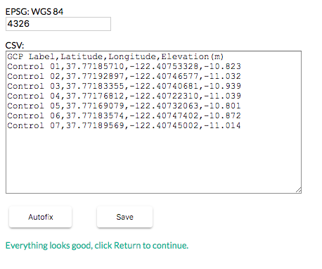
In-Browser Tagging: Verify your .CSV

Your GCP .CSV will either be successfully read by our auto-tagging tool or you'll need to tag your own points.

If we encounter a problem with your .CSV or EPSG code, you will receive a red error at the bottom of the coordinate box. There are multiple reasons why your GCP data may throw an error. 

Here is what the GCP .CSV Editor will look like in your browser.


Once your GCP data is accurate you will continue to select and tag your points! 


How to Skip a GCP While Tagging

Because sites change frequently, sometimes a target will no longer be visible on an active project. If you need to skip a GCP you can do so by clicking on the "Skip GCP" in the upper right-hand corner during the initial workflow of finding the target within the map. This can greatly improve the accuracy of the overall map once it has been processed with GCPs.


How can I improve it?

Thank you to everyone who is making GCP maps with DroneDeploy. By tagging the GCP targets in your images, you are providing valuable training data that can make Ground Control AI smarter and faster. The tool will never be able to match every type of target in every situation, but by correcting targets that the assistant gets wrong, and accepting targets that it gets right, you will improve the performance for everyone.


Can I opt out?

If you do not want to be part of the Ground Control AI feature, you are able to opt out by contacting the support team. Support@dronedeploy.com


Articles in this section

Was this article helpful?
0 out of 0 found this helpful