Terrain Awareness offers increased flight confidence and easy flight planning over complex terrain for improved map quality. It helps pilots improve map quality over varied terrain with equal resolution and less likelihood of holes at higher elevations.
Terrain Awareness enables the drone to follow the terrain throughout the mapping flight, keeping the camera a consistent distance from the ground. This maintains consistent overlap and ground sample distance (GSD), which is essential for higher-quality map processing results.
Availability: who has access?
available for all DroneDeploy accounts (free and paid)
Terrain Awareness is available on Map, Corridor, and Stand Count plans and, as of February 2026, now supports projects up to 2,000 acres (no longer limited to 200 acres). It works across all platforms, including web, iOS, Android, and Smart Controller.
Enabling terrain awareness on your flight plan
To enable or disable Terrain Awareness, tap the button next to the flight altitude indicator.
When Terrain Awareness is turned on for the flight plan, the button will be highlighted blue.
When Terrain Awareness is disabled, the button will be grey.
If Terrain Awareness is disabled, but a conflict is detected due to elevation changes, the indicator will turn red.
When you tap the Terrain Awareness button, you can view the drone path and elevation as compared to your terrain.
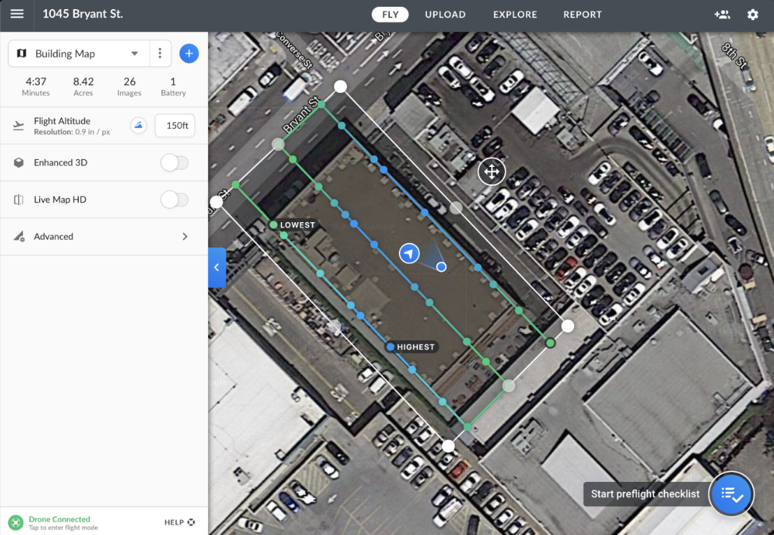
When Terrain Awareness is enabled, the color of your flight plan will indicate the elevation changes as you fly, marking the Highest (blue) and Lowest (green) points.
When Terrain Awareness is disabled, the chart will still show you how your drone will fly in relation to the ground and detect potential conflicts.
Key features and details
Terrain Awareness is a powerful tool that helps ensure consistent data quality over uneven landscapes:
Consistent Ground Sample Distance (GSD): It keeps the camera a consistent distance from the ground, ensuring uniform image resolution across the entire site.
Consistent Overlap: By following the terrain, it eliminates discrepancies in overlap that typically occur in sites with high topographic relief, which is critical for successful map stitching.
Offline Functionality: Terrain Awareness is available for use offline. As long as Terrain Awareness is enabled when your mobile device is online, the terrain data will be downloaded to the device for offline use.
Risk Mitigation: It reduces the risk and expense of having to re-fly a site due to overlap issues and minimizes processing times by providing reliable data.
Limitations and considerations
Terrain Awareness is available for plans under 2,000 acres.
It is important to check the elevation change with the flight lines to make sure everything looks correct before flying.
Due to limitations in the aircraft, the DJI SDK, the source data, and real-world obstacles, any terrain-aware flight should be carefully reviewed and verified before taking off.
Terrain Awareness will not adjust for objects, such as tall buildings or trees, that are on the terrain.
FAQs
Q: Does Terrain Awareness work offline?
A: Yes—Terrain Awareness is available for offline use. As long as it is enabled when your mobile device is connected to the internet, the terrain data will be downloaded to the device.
Q: Why is consistent overlap important?
A: Consistent overlap ensures a better map stitch and leads to consistent GSD and higher quality map processing results.
V2.2